Four WyomingView sponsored students presented their research about the urban heat island effect, image analyst bias and utility of indices to map water bodies in the recently concluded 2013 GeCo West Conference in Laramie, WY. WyomingView coordinator mentored these students on these projects.
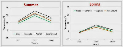
Sarah Arulswamy, a 9th grade student at Laramie Junior High School, has been studying the urban heat island effects in Laramie since summer 2012. Earlier she presented her findings based on summer, fall and winter data in the 2013 Wyoming Science Fair. She continued her study in spring 2013 and presented the findings in this conference. Urban heat island effect was evident in spring but at a much lesser magnitude than what she observed in 2012 summer (Figure below).
Bailey Terry (BS Rangeland Ecology & Watershed Management) has been estimating analyst bias introduced during Landsat image classification. She described how small differences introduced by the analysts during the interpretation process influences area estimates of earth surface features.
Kaitlyn McCollum (MS Agricultural Economics) and Matthew Thoman (BS Rangeland Ecology & Watershed Management) tested the transferability of threshold values of commonly used indices for mapping water bodies. In their talk they described how well threshold values generated for one water body can be transferred to other water bodies in space and time.
Additional photos from these presentations can be found at WyomingView’s Google+ site.


