 |
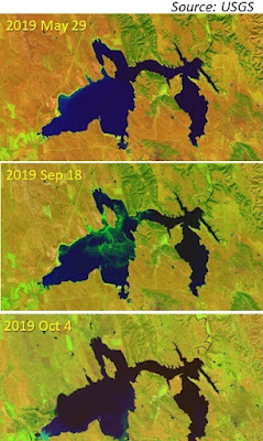
| Landsat images acquired in2019 show algal blooms in Keyhole Res. Wyo. These blooms form under abundant sunlight, temperature and nutrients. Landsat images are available from US Geological Survey. |
Third graders in the Spring Creek Elementary School (Laramie, WY) learned how satellite images are used for tracking algal blooms in waterbodies throughout the US.
Students in 3rd grade GATE science class are learning about water and sources of water pollution. Currently they are finding solutions to address environmental issues such as oil spills, acidic conditions, and harmful algal blooms.
First, students learned the sources of chemicals that would eventually become the nutrients for the algae once they enter waterbodies. Algal blooms appear when there is an abundance of sunlight and higher temperatures.
Next, they saw how algal blooms appear in images captured by Landsat and other satellites. Aerial and satellite images provided by USGS, NASA, and several state environmental agencies were used for this outreach event. These satellite images showed algal blooms in small and large waterbodies throughout the US.
Describing the value of this outreach activity, Ms. Natalie Davis, their teacher commented “provided students with real life data and imaging that brought all the work we did in class. Students were able to see real examples of the impact water pollution has, and tie that back to what they had been testing/studying in class the weeks prior”.
This outreach event was conducted virtually on Sept 23, 2020 due to COVID-19 restrictions.

